Getting caught in flash flooding, facing understaffed emergency management teams, and delayed project timelines are all potential realities cities face when a heavy rainfall event occurs. Every year from May to September, the Denver area experiences these
types of heavy rainfall events and is faced with these exact frustrations. To alleviate some of these pain points and better prepare, we created an early alert tool to anticipate the daily heavy rainfall threat over the Denver metro area.
The Heavy Rainfall Threat Analysis Tool
The flood warning system, created in 2015, is called the Heavy Rainfall Threat Analysis tool. It is nicknamed the Quantitative Precipitation Forecast (QPF) Max because one of its main functions is to realistically predict the “worst-case scenario”,
or the maximum amount of rain that is to be expected. The tool was also created to accurately discriminate between the lower and higher flood threat days. To do this, QPF Max creates probabilistic precipitation forecasts over different forecast zones
within the Denver Metro area. In order to create the most robust and accurate probabilistic forecast, high-resolution numerical weather models are taken from several government agencies, some of which are not used operationally by the National Weather
Service. The tool updates three times throughout the day so that the latest model runs are incorporated into the forecasts. The first of these forecasts comes out at 8 a.m., which gives a city time to prepare for a potential event.
With this ensemble, the tool can predict what areas can expect the greatest threat, the timing of the heaviest rainfall, the intensity of the storms, and the probability or confidence that heavy rainfall will even occur. The early alert aspect of the
tool gives emergency managers time to prepare, organize resources, assess the need for on-call staff, and warn the public of any potential flooding. It can also be beneficial for engineers and project managers. If teams know that they are performing
work in a creek bed, they can use the tool to move materials out of harm’s way or change the work plan because of the potential for flooding.
How is it Helping Today?
The Mile-High Flood District is a 5,700-square-mile zone around Denver’s metro area and is home to nearly three million people. On September 6, 2019, the Heavy Rainfall Threat Analysis tool properly predicted, not one, but two areas that received
heavy rainfall and subsequent flooding during the afternoon and evening hours. Both areas were well highlighted with “high” and “very high” threats after the 8:00 a.m. forecast. The tool also accurately predicted the timing
of the events and placed the southern foothill’s event in a three-hour window. After the afternoon flooding event occurred in the foothills, the third update of the day properly dropped the threat over that area and focused only on the heavy
rainfall event over the south metro area.
The tool can predict what areas can expect the greatest threat, the timing of the heaviest rainfall, the intensity of the storms, and the probability or confidence that heavy rainfall will even occur.”
Dana McGlone
Continued Development
While our confidence in the tool grows after each accurately predicted event, every year the tool is improved with updates and adjustments. This includes revising the algorithms that produce the QPF Max and using local data from the client’s rain
gauge network to make bias corrections to the numerical weather models. The bias correction allows the tool to be fine-tuned to the Denver metro area, more accurately predict the probability of a heavy rainfall event, and helps improve the QPF Max.
Additionally, the tools’ forecasts are completely automated, which makes it cost-friendly for the client.
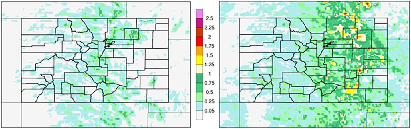
The benefit of an ensemble has been well documented and is especially noticeable on marginal rainfall days, which characterize a large part of the Denver area climate. The multimodel solution or ensemble (right) shows that most of eastern Colorado has
the potential for a heavy rainfall event, while the one-model solution (left) only shows the heavy rainfall potential over a small portion of the northeast plains.