Having high quality and accurate 3D elevation data (both topographic and bathymetric) means federal agencies, including the National Oceanic and Atmospheric Administration (NOAA) and the U.S. Geological Survey (USGS), can better prioritize and direct investment dollars to address user and community needs. For example, this might include a local community in rural Alabama that needs 5G infrastructure upgrades. Without current and accurate 3D elevation data, those upgrades would be extremely difficult for a telecom provider to implement.
The vision of a 3D Nation is to make communities more resilient and the U.S. economy more competitive by building a modern, accurate elevation foundation from our highest mountains to our deepest oceans. 3D Nation unites terrestrial and ocean/coastal mapping agencies in common purpose to achieve an authoritative national geospatial foundation in support of national mapping needs.
Sourcing Information and Data
Study participants included 45 federal agencies, private industry, academic institutions, 56 state and territorial governments, and tribal entities. Results of the study indicated that an improved national elevation program has the potential to generate $13.5 billion in new benefits each year once fully funded and operational. Our team of geospatial and technology solutions professionals worked with the NOAA Office of Coast Survey (OCS), USGS, and partner mapping agencies on the 3D Elevation Program (3DEP), to conduct the study to assess how improved 3D elevation data and related products could benefit the nation.
Collection Process
Our team collected more than 1,350 responses from federal agencies, commissions, non-profits, private and commercial entities, and local, state, and tribal governments from across the 50 states, Washington, D.C., Puerto Rico, U.S. Virgin Islands, Guam, American Samoa, and Northern Mariana Islands. This diverse pool of participants was asked to provide detailed information about the elevation data required to accomplish their missions, including:
- Quality level
- Horizontal and vertical accuracy
- Update frequency
- Hydrologic processing
- Tide correction
- Seamlessness between datasets
- Data products or derivatives
Survey participants were also asked about the importance of integration between elevation data and other datasets. We collected responses regarding elevation data access methods, including required data types or file formats. Study respondents reported what future annual benefits they anticipate from an enhanced data program.
Elevation data is integral to a variety of mission-critical activities performed throughout the U.S., and this report gives NOAA and USGS a greater understanding of the requirements and benefits associated with potential enhancements to a national elevation data program, one that—if all reported requirements were met—would help users realize an estimated $13.5 billion in annual program benefits.”
Sue Hoegberg
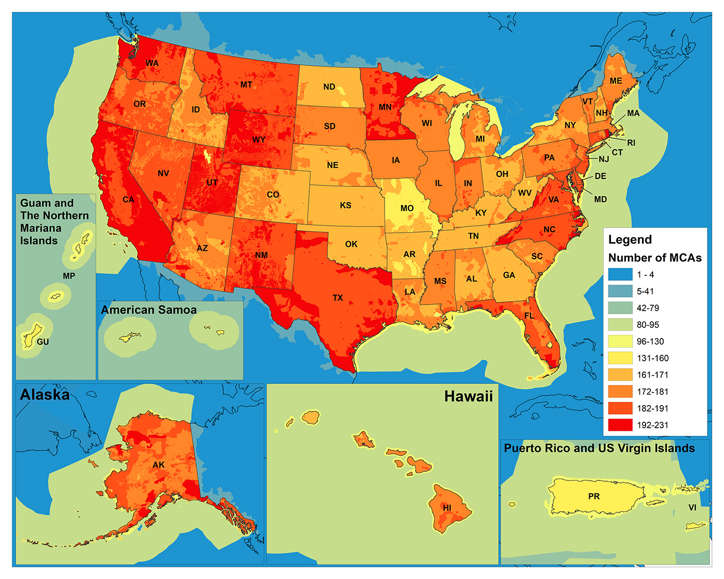 This map is a visualization of the total number of mission-critical activities by region, on and offshore. Image copyright, NOAA.
Top Uses for Elevation Data
Sponsored by NOAA and USGS, the study was conducted to establish a baseline understanding of national business uses, needs, and associated benefits for both topographic and bathymetric national elevation data, and to inform the design of enhanced future programs that balance requirements, benefits, and costs. Based on this study’s results, the top business uses of elevation data are to manage the coastal zone, homeland security and disaster response, flood risks, infrastructure and construction, geologic hazards, urban and regional planning, natural resources conservation, marine and riverine navigation and safety, sea level rise, and water quality—ten uses that account for almost $13 billion of the estimated future annual benefits.