On August 30, 2021, as Hurricane Ida moved along the East Coast, New York City experienced 3.15 inches of rain in a single hour, shattering the previous record that had been broken just 10 days earlier with Tropical Storm Henri. This rainfall event occurred
during what was the second rainiest summer on record for New York City. As high-intensity rainfall records like this are being broken across the country, we need to change how we plan for this hazard.
We are challenged by the ability to capture and communicate the variability of high-intensity and high-volume rainfall and the probability of these kinds of events, including 100-year or 500-year design storms. For example, what might be the impact of
six inches of rain in four hours versus four inches of rain in one hour? Heavy rainfall also presents modeling challenges that are unique to different geographies, such as coastal versus riverine environments. Particularly in urban settings, the existing
stormwater infrastructure design and capacity to handle heavy rainfall events is a key component of understanding pluvial flood risk.
As a result of changes in rainfall frequency and duration, there are widespread impacts to transportation systems, homes, community safety, and access to emergency services. We’ve worked recently with localities to change how we think and talk about
these kinds of events. Our framework includes:
- Characterizing the nature of a hazard scenario
- Assessing vulnerability of key assets and lifelines
- Developing strategies
- Prioritizing solutions to draw down vulnerabilities
Characterizing Heavy Rainfall for Local Government and Federal Projects
Short-burst storm events can be highly localized. Temporally and spatially variable rainfall datasets and scenarios can be helpful tools for characterizing heavy rainfall. We are supporting both Frederick and Cecil counties in Maryland with these tools.
In Frederick County, our firm is helping staff characterize and describe the nature of pluvial flooding and identify flood mitigation strategies. Our efforts began in a pilot area, the Clover Hill subdivision, and have expanded to a countywide analysis
as part of its hazard mitigation plan update.
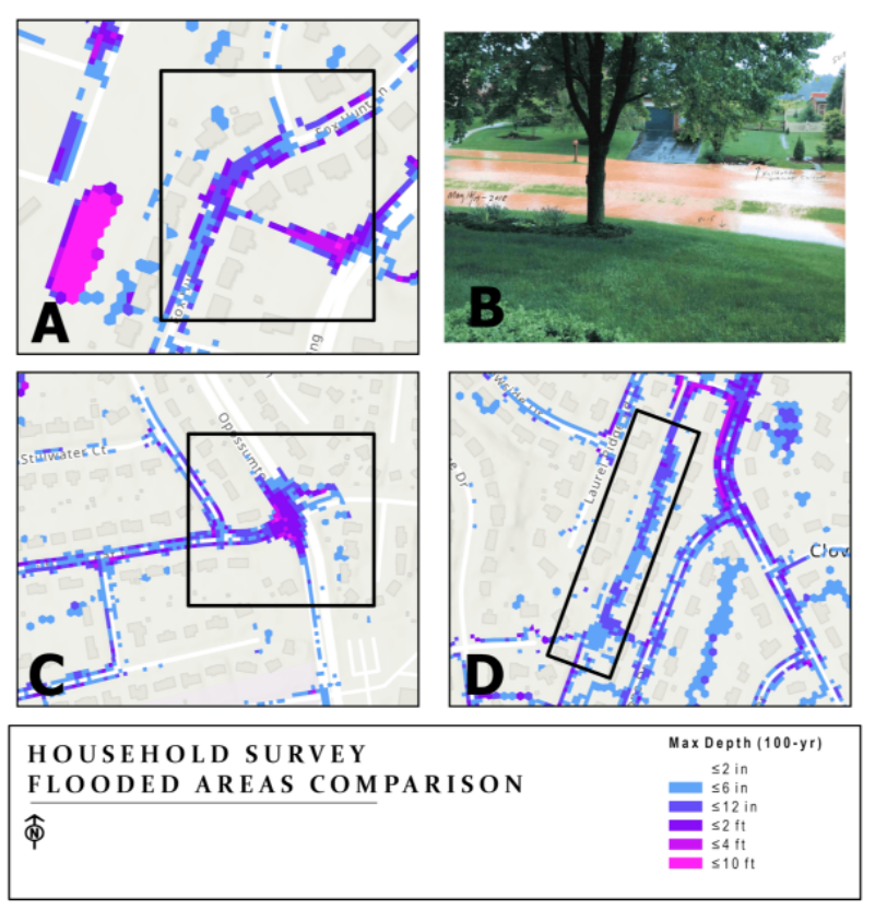 The images display a close up of the 100-Year storm event simulation results, which matched the experiences of the Clover Hill residents based on responses received from the landowner flooding surveys that were mailed in November 2019. More information
is available on the Frederick County, Maryland, website.
The images display a close up of the 100-Year storm event simulation results, which matched the experiences of the Clover Hill residents based on responses received from the landowner flooding surveys that were mailed in November 2019. More information
is available on the Frederick County, Maryland, website.
In Cecil County, our firm is evaluating the results of current and future hydrologic and hydraulic analyses to better understand flood hazards, forecast flood vulnerabilities for a range of extreme precipitation events, and identify an array of mitigation
opportunities. Even without stormwater infrastructure like curbs, gutters, and a pipe network, our models were able to illustrate how heavy rainfall event scenarios impact a variety of locations throughout both communities.
In another effort that supported the United States Army Corps of Engineers (USACE) Baltimore District and U.S. Navy climate resilience mission for federal facilities, our firm completed a climate vulnerability assessment that accounted for combined sea
level rise and rainfall-based flooding impacts for the U.S. Naval Academy facility in Annapolis, Maryland. This included developing a 2D urban stormwater model (XPSWMM) to simulate pluvial and tidal flooding impacts, considering the 10-year, 24-hour
rainfall event combined with future sea level rise. Based on these conditions, courses of action were identified that will be able to mitigate flood risk within the Naval Academy facility. Proposed flood risk management strategies included:
- Improving stormwater conveyance
- Adding a pump station and perimeter floodwall
- Strategically locating additional subsurface storage to store stormwater runoff
- Delaying peaks
- Mitigating overland flooding
Even without stormwater infrastructure like curbs, gutters, and a pipe network, our models were able to illustrate how heavy rainfall event scenarios impact a variety of locations throughout both communities. "
Mathew Mampara, Ashley Gordon, and Katie Gronsky
Developing Right-Sized Project Solutions
We worked with the New York City Department of Design and Construction (NYCDDC) and Office of Recovery and Resiliency (ORR) to develop climate resilience design guidelines for the city’s capital projects. The guidelines provide onsite stormwater
management guidance to address heavy rainfall events and integrate green infrastructure and stormwater best management practices (BMPs) to plan for increases in rainfall intensities and frequencies. The guidelines also include a toolkit with an exposure
screening tool and benefit-cost analysis methodology to support resilient design strategy and project investment decisions.
Another example of supporting solutions to heavy rainfall at the local scale included our work in Virginia Beach. Our team conducted an analysis of historical and future precipitation that showed increasing heavy rainfall events in the city. This analysis
led to the city updating its Public Works Design Standards Manual to include design rainfall depths that are 20% over the existing value in National Oceanic and Atmospheric Administration (NOAA) Atlas 14, which is a record of precipitation frequency
estimates published in regional volumes for the U.S. and affiliated territories. The Commonwealth of Virginia is coordinating with other states to update the NOAA Atlas 14 analysis that informs infrastructure design.
Similarly, through our work developing the Virginia Coastal Resilience Master Plan, we heard concerns about heavy rainfall at public meetings held in the summer of 2021. Building off the master plan, the Commonwealth will perform a future condition rainfall
flooding analysis that will expand upon the coastal hazard analysis and impact assessment completed during phase one.
Extreme rainfall is an increasingly important component of understanding flood hazards that has been underdeveloped, in part due to its complexity. By continuing to characterize heavy rainfall and disseminate information about the nature of the impacts, we can further support communities by developing project-specific solutions to dynamic flood hazards.