In February 2017, the Oroville Dam, located east of the Sacramento Valley in California, had a spillway failure following Northern California's wettest winter in over 100 years. The initial spillway flow had been increased to 50,000 cubic feet per second to accommodate the increase in water volume. Then dam employees discovered a large erosion on the main concrete spillway, forcing them to divert much of the water to the emergency spillway. As a precaution, close to 200,000 people living in communities downstream of the dam were ordered to evacuate, given the possibility of a failure of the emergency spillway.
As a result of this near-disaster incident, on October 19, 2017, following the passing of Senate Bill 92 (SB92) in California, emergency regulations were adopted to provide standards for preparing and submitting inundation maps to the Division of Safety of Dams (DSOD). The main objective of SB92 is to identify the potential hazards downstream of dams by requiring inundation maps and emergency action plans (EAPs). An inundation map is one that shows where flooding may occur over a range of water levels near a community's local stream or river. The dam-breach inundation maps, once approved by DSOD, are available online for public view, including the Oroville Dam map. The maps will support the development of EAPs, which are also required for all dams, except those with a low-hazard designation. EAPs are reviewed and approved by the California Governor's Office of Emergency Services (Cal OES). Both public and private dams need to have inundation maps and EAPs updated every ten years.
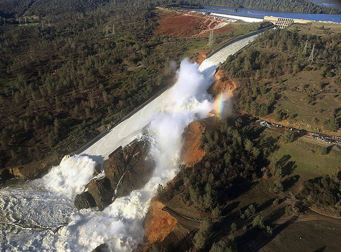
Erosion on Oroville's main spillway.
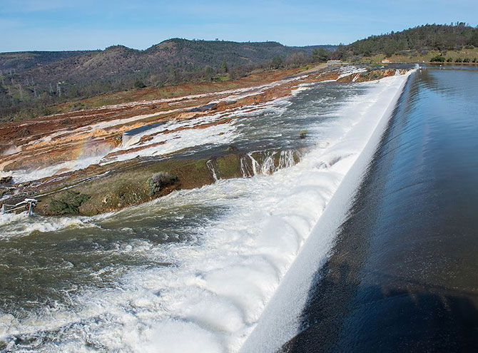
Oroville's emergency spillway in action.
Challenges Still Remain
One area that we continue to see challenges with is the cost of maintenance of our nation's dams. According to the Department of Water Resources, the cost of fixing the Oroville Dam's spillway is expected to cost upward of $1 billion. For privately owned dams, safety assessment studies can cost up to $100,000. This becomes an issue for dams that can sometimes be close to 100 years old that need to be assessed, but have owners that are unable to afford the high prices of compliance. According to a study by the American Society of Civil Engineers, 70 percent of dams in the U.S. are more than 50 years old. Information on the dams themselves is not always available, particularly with older, smaller, privately owned dams. In-person site visits by the engineers are necessary, adding additional financial burden for the dam owners.
Additionally, high-quality data such as lidar or survey-based topographic data-though always desired by the engineers to improve the models-is not always available and can be quite expensive to collect. Fortunately, at an absolute minimum, lower resolution topographic is available for free on the U.S. Geological Survey's (USGS) website and is admissible when no higher quality data is available. Another key data point is the storage-elevation relationship of reservoirs needs to reflect the actual condition as much as possible so bathymetry or underwater surveys may be required, thus increasing the cost of the project.
A Future in Technology
Today's technology is helping us to map hypothetical dam failures to make our communities safer. For example, on a recent job we used lidar topographic data for developing a dam breach model and a dam breach inundation map for Silver Lake in Plumas County, California. This type of topographic data is of higher resolution than the free version of topographic data available on USGS website, allowing us to develop better models. Simulating dam breach scenarios requires a high level of hydraulic engineering expertise with the use of the best available data and the most appropriate modeling tools.
Another one of our latest tools is the Hydrologic Engineering Center's River Analysis System (HEC-RAS), which is provided by the U.S. Army Corps of Engineers. This software allows us to perform one-dimensional and two-dimensional unsteady flow calculations, sediment transport/mobile bed computations, and water temperature/water quality modeling. This technology provides a robust and accurate way to simulate a variety of dam breach scenarios.