In my last blog I discussed my involvement on the National Oceanic and Atmospheric Administration's (NOAA) Hydrographic Services Review Panel. As a member of this panel, I have also co-lead the Planning and Engagement working group, which works to identify issues and recommend solutions for our nation's ports and harbours.
Massive Ships and Clogged Ports
Relevant to many of our issue papers, there are hundreds of megaships transiting our oceans (cruise ships, ultra-large crude and ore carriers, and ultra-large container vessels that carry more than 18,000 containers), many of which are longer than America's longest aircraft carriers. Most ports and harbors are challenged to take special mitigating procedures in order to handle them safely. Megaships routinely enter ports that were designed for smaller ships, and sometimes have only a foot of under-keel clearance, side-clearance, or overhead clearance. A vessel's overhead clearance is the distance in excess of the air draft, which allows a vessel to pass safely under a bridge. These tight clearances triggered one of our recent issue paper, Making Precision Navigation the New Norm in Approaches and Ports.
Issue Paper at Play
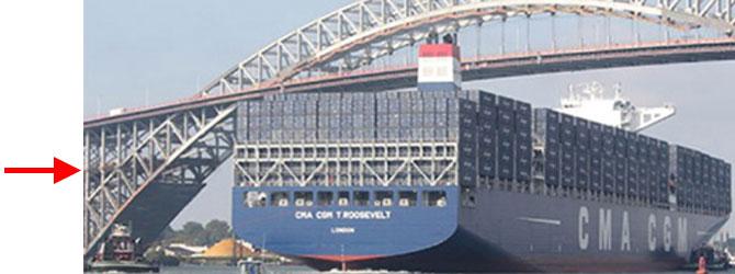
The image below shows the "new" Bayonne Bridge and remaining parts of the "old" bridge with its prior 151-foot air draft. After a seven-year and $1.6 billion investment to elevate the roadbed 65 feet to its new 216-foot air draft, the channel can now accommodate the world's largest vessels. Although the channel was deepened to 50 feet, the narrow channel could not be widened, resulting in a continuous need to enforce restrictive navigation and operating procedures while megaships are operating in the waterways. Vessels must still make several relatively sharp turns to get to and from the terminals in Newark Bay, and wind and current can be extremely impactful on the actual time of operation.
 The 14,000 ton, 1,200-foot long CMA/CGM Theodore Roosevelt passing beneath the "new" Bayonne Bridge with its 160-foot beam. The red arrow indicates the height of the previous roadbed. Photo courtesy of Edward J. Kelly, Maritime Association of the Port of NY/NJ.
A Diverse, Focused Team
By bringing together professionals who serve in many different facets of the industry, we're able to better explore possible solutions, data analyses methods, and research techniques. These professionals are experts in their fields, including oceanography, arctic policy, maritime transportation and security, hydrographic and ocean mapping, geodesy and remote sensing, marine pilotage, hydrographic surveying, dredging, and navigation. I'm proud to serve alongside such esteemed professionals as we work towards preserving our planet and protecting aquatic ecosystems and human lives as mariners travel through our nation's waterways.