Recent climate data suggests that weather events are making travel more hazardous. Increasing hazards associated with higher intensity weather events, including floods, droughts, and wildfires highlight the importance of the steps federal agencies, states, local communities, and businesses are taking to address risks related to the changing climate. While preparations are being made on the public’s behalf, there are also steps you can take to prepare yourself from the immediate impacts of these climate events. In Colorado, our firm helps support numerous tools and strategies to help keep you safe from the risks out on the road.
While preparations are being made on the public’s behalf, there are also steps you can take to prepare yourself from the immediate impacts of these climate events. ”
Ken Cecil, Maggie Mathis, and David Sutley
The Colorado Flood Threat Bulletin
Our firm has long been at the forefront assessing risks from natural hazards. This starts with the forecast we prepare and publish daily May through November via the Flood Threat Bulletin. This bulletin and COtrip, another Colorado travel conditions announcement website, help Colorado communities stay ahead of road conditions and closures which are increasing following the large number of wildfires we’ve experienced over the past year. Those wildfires have increased runoff caused by the loss of vegetation which provides natural runoff protection.
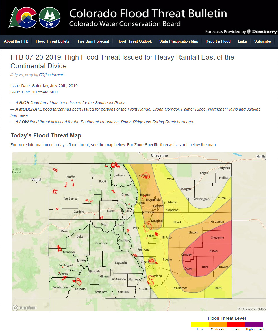
 This is an example of our daily Flood Bulletin entries.
Looking to the future, our firm will expand on the information provided in the Colorado Flood Threat Bulletin to include the ability to take real-time flood forecast data that we are generating and provide analysis on impacts to our infrastructure. This approach is similar to how the FloodCast tool that our firm helped develop is helping improve state flood planning, risk management, mitigation, preparedness operations, and emergency response activities.
Preparing Our Infrastructure from Future Climate Stressors
In addition to preparing the public for climate threats through tools like the Flood Threat Bulletin, we are also working with federal and state agencies to better understand the impact of climate change on roads, bridges, and other transportation infrastructure and issue practice-oriented guidelines across the country. Transportation engineers typically design infrastructure to withstand flooding up to a “design flood event,” such as the 100-year flood, which is calculated using historic data on a regional basis. The intensity of extreme rainfall, however, is likely to increase across the country due to climate change, which needs to be factored into the design flood calculation, especially when infrastructure has a long service life. Unfortunately, current engineering guidance does not typically provide methods to incorporate information about future climate change into design calculations.
To address this challenge, the National Cooperative Highway Research Program (NCHRP) convened experts to produce the recently released design practices guide Applying Climate Change Information to Hydrologic and Coastal Design of Transportation Infrastructure. The design practices guide is a practical, step-by-step manual for hydrology and hydraulic engineers at state departments of transportation (DOTs) and their implementing partners. The steps include choosing the level of analysis, selecting the appropriate climate scenarios, finding the best-available climate data, and using available data to estimate the design discharge or flood event. To evaluate and improve the design practices guide, the NCHRP contracted our firm to work with state DOTs to apply them to existing and planned infrastructure projects. A total of eight projects are underway, including a Colorado DOT project analyzing bridge scour under projected climate change across the state.
Simple Preparation Steps to Take Before Leaving Your Home
Despite your busy schedules, it’s important for you to take a moment to assess road conditions, check your vehicle safety, and pack the necessary provisions by following these steps:
- For Colorado residents, check the Colorado Flood Threat Bulletin
- Check the National Oceanic and Atmospheric Administration (NOAA) website for weather conditions
- Check the Federal Highway Administration (FHWA) website for road conditions, closures, and detours
- Review your vehicle conditions by visiting the National Highway Traffic Safety Administration (NHTSA) website for advice on tire pressure, tire tread, fluid levels, and ensure spare tire/jack are functional, etc.
- Pack water, snacks, jacket or blanket, first aid, and roadside emergency kit
- Tell someone where you’re going. If possible, provide them your route, dates, and destination.
If you would like to find out more information about our flood resilience work with departments of transportation out west, you can register to join David Sutley for a presentation at the Colorado Association of Stormwater and Floodplain Managers (CASFM) 2021 Conference.