When approaching a new development, owners want to understand what’s possible, what constraints exist, what it will cost, and what challenges may arise throughout the project’s life cycle. Conceptual land planning helps owners to understand a site’s opportunities and constraints early and avoid unwanted surprises later.
A conceptual land plan is a high-level, strategic plan that serves as a preliminary framework for how a site may be developed. We use these plans to develop a vision, explore the potential of a site, define land uses, identify site constraints, and outline infrastructure needs, while also considering regulatory requirements, local politics, and economic feasibility.
As development costs rise across the U.S., conceptual land planning can help owners prevent costly redesigns, avoid construction delays, and reduce material waste. By embedding early planning into a land development project, we can help our clients reduce risk and make smarter, more informed investment decisions.
What Role Does Preliminary Site Analysis and Due Diligence Play in Concept Plans?
We often begin the conceptual planning phase with an analysis of publicly available geographic information system (GIS) data. Our teams use this information to develop a concept that aligns with both the client’s program and the jurisdiction’s comprehensive plan.
Through this preliminary site analysis, we can identify potential constraints before more fieldwork is necessary, helping us determine when it makes sense to engage survey teams, wetland scientists, transportation design professionals, and other specialists. This preliminary analysis can help clients save money in the early stages of a project while also helping inform decisions further down the road.
We then build on this analysis through due diligence, evaluating whether the concept is compliant, feasible, and economically viable. Depending on the type of development – whether residential, commercial, or industrial – there may be different regulatory requirements or environmental considerations. Our teams view due diligence as an extra layer to mitigate risk before construction begins.
Why Does Local Knowledge Matter in Early Planning?
In addition to site analysis and due diligence, local experience and expertise can be particularly valuable, especially when it comes to navigating the development approval process by a local board or council. With zoning applications becoming very costly to process across the U.S., knowing what community leaders value can make a significant difference for getting a proposed development approved and off the ground.
Similarly, communicating with nearby residents and staying informed about local news can provide valuable insight in the early stages of a project. Understanding community expectations for a new development, as well as recurring concerns or issues within the community, can help us shape a concept that responds to local priorities and addresses potential concerns before they arise during the review process.
Finally, we look closely at a jurisdiction’s future plans and economic goals. Understanding how the jurisdiction envisions the future use of the site and surrounding areas can help us identify opportunities and constraints and inform comprehensive decisions about land use and infrastructure needs.
How Can an Early Environmental Review Shape Development Design?
Also included in a county’s comprehensive plan is an environment section that outlines policies and initiatives for protecting natural resources while accommodating new development. During the conceptual phase, our team uses this guidance to evaluate a site’s natural features, such as wetlands, significant plant communities, floodplains, and other environmentally sensitive areas. By considering these features early on, we can shape developments to minimize impacts and preserve important natural resources.
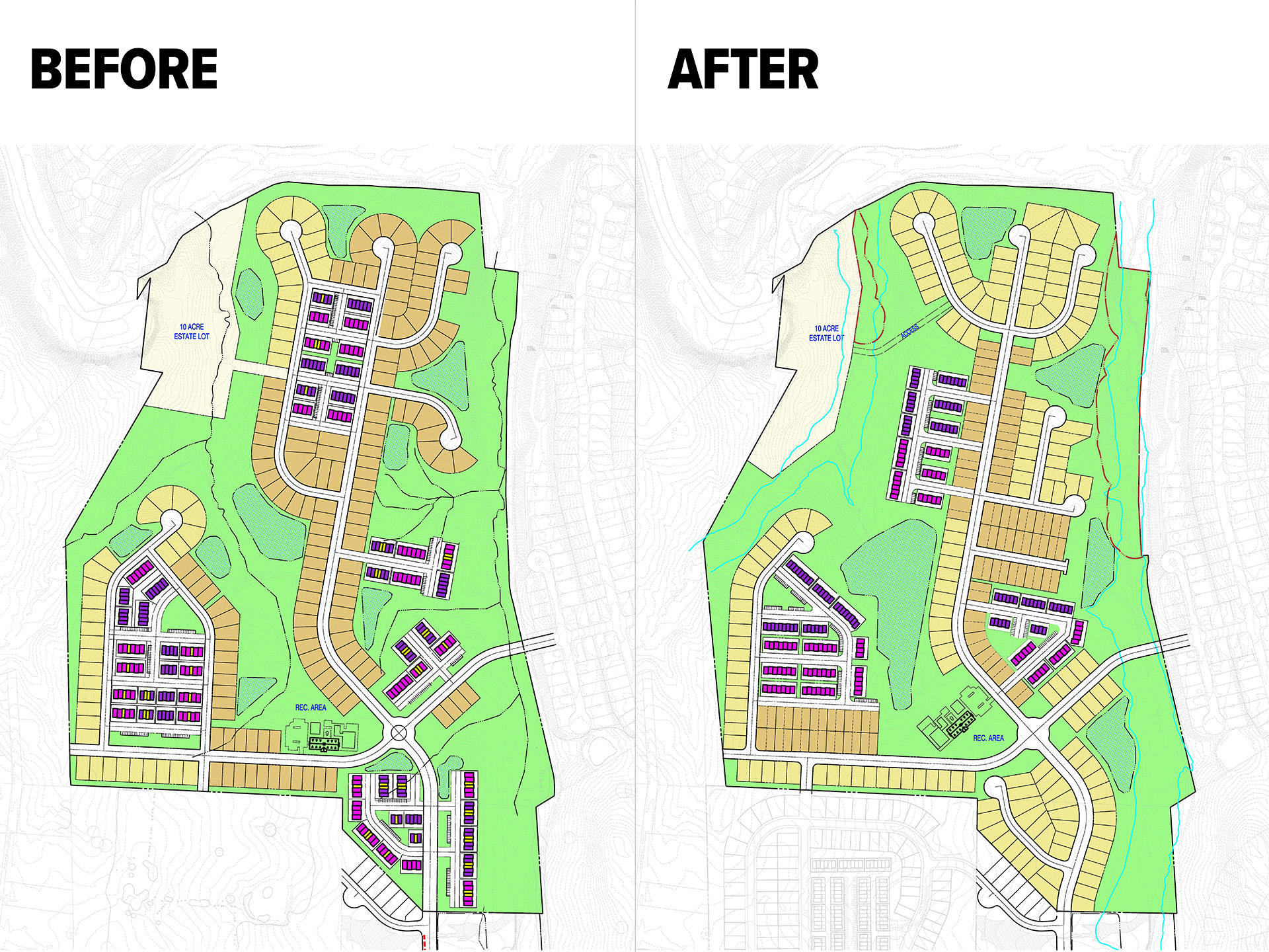
For a recent residential development in Virginia, we created a conceptual land plan using county GIS data. Before finalizing the design, we identified potential environmental concerns that warranted a closer look. We brought together the team’s surveyors, wetland scientists, and site/civil engineers to ground truth the GIS data in the field, a process of validating remotely collected data through on-site observations and documentation. This collaborative approach helped us identify areas to avoid or minimize impacts to environmentally sensitive resources, anticipate permitting requirements, and refine the site layout.
Stormwater management is one of many considerations that can be overlooked in the early stages of development. While we want to maximize a site’s potential, necessary infrastructure can have a significant impact on a client’s overall return on investment. Conceptual land planning provides an opportunity to look at a site holistically. By accounting for stormwater management, environmental constraints, and other site requirements early in the design process, our team can develop a more realistic picture of a site’s potential and identify opportunities to make the most effective use of the land.