For most people in the U.S., water is something that comes out their taps, and they pay very little attention to it unless there is a storm and suddenly they are flooded, or there is a drought and suddenly they can no longer water their lawns. But
to stormwater engineers and water resource professionals at Dewberry, water is the life blood of the country, and managing water as a resource is one of our major objectives.
Although the U.S. Geological Survey (USGS) has been mapping the veins and arteries of the nation’s lifeblood waterways, it was not until 2000 that through a collaborative effort between USGS, the Environmental Protection Agency (EPA), and several
cooperating states, that the first National Hydrography Dataset (NHD) was released. The NHD provided for the first time a rich set of named surface water features for making maps, a robust stream-addressing scheme for linking water-related features
to streams, and a national stream network for discovering and analyzing these linked data through upstream and downstream searches.
All was great until improvements in ortho-photography in the late 2000s emerged as well as the use of high-resolution ortho-imagery and lidar-derived topography. Then in 2012, USGS initiated the 3D Elevation Program (3DEP) to provide high-resolution topographic
data for the nation, and the NHD lines did not match either ortho-imagery or the new lidar-based topography. NHD flowlines and waterbodies simply did not line-up with the lidar-based digital elevation models (DEMs). That means it was time to update
the NHD.
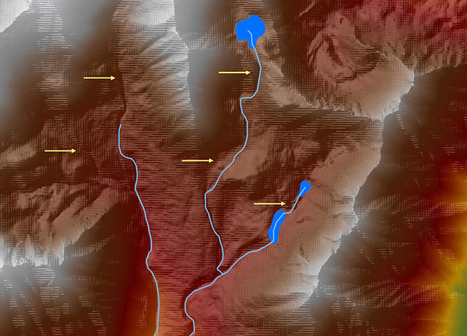
Current NHDPlus stream network for an upper reach in Alaska. Yellow arrows point to areas where the NHDPlus flowlines do not follow the elevation data.
A History on NHD
During the late 1990s, the Federal Geographic Data Committee (FGDC) developed a Sub-committee Spatial Water Data (SSWD) to foster a collaboration among federal and state agencies interested in water-related national geospatial data efforts. These efforts
included NHD, the Watershed Boundary Dataset (WBD), and the National Elevation Dataset (NED). The release of these datasets has played an increasingly important role in the management of national waters.
The initial NHD was released in 2000 and captured the hydrography at a 1:100,000 scale. The success of NHD led to numerous federal and state agencies clamoring for higher resolution (1:24,000 scale or better; 1:63,360 in Alaska) NHD, with additional
tools to support estimation of stream flow volume and velocity. This led to the release of NHDPlus in 2007. More recent updates to NHD brought new feature attributes and spatial relationships to the network. The next generation of NHD—NHDPlus
High Resolution (HR)—is currently being developed to incorporate hydrography and the elevation datasets as Elevation-Derived Hydrography (EDH).
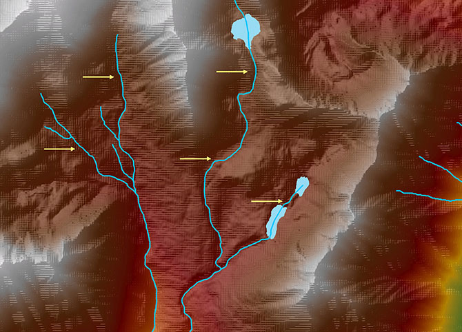
Dewberry’s semi-automated NHDPlus HR flowlines for the same reach. The flowlines follow the terrain and there is additional resolution in the western reach that was missing from the 2007 NHDPlus.
Using IFSAR to Update NHD in Alaska
One of the most time consuming and challenging aspects of updating the NHD to the NHDPlus HR is automating the updating process to accommodate high-resolution lidar, particularly Interferometric Synthetic-Aperature Radar (IfSAR) data, which was collected
in Alaska. We recently completed the USGS QL5 IfSAR mapping of more than 570,000 square miles of the state. The challenge is to use the IfSAR-derived DEMs to reconstruct the NHD from the most remote and rugged state in the nation.
We were selected by the USGS to produce a pilot project of approximately 2,000 square miles in one hydrological unit, in order to develop the processing steps necessary to update this important dataset.