According to the U.S. National Oceanic and Atmospheric Administration (NOAA), as of the 2010 census 39 percent of the nation's population lived in counties with coastal shorelines. Today the number has increased to nearly 50 percent. The economic and strategic importance of coastal areas in the U.S. cannot be overstated: coastal communities host military facilities, ports, centers of commerce, industrial and manufacturing facilities, local businesses, and tourist attractions to name a few. Existing coastal and civil engineering infrastructure designed to protect communities from storm events must now also contend with added risk from sea level rise and increased demand on drainage systems as populations grow. The need to update these infrastructure systems is urgent, requiring long- and short-term action plans to protect these communities.
In many coastal areas, it has become common practice for homeowners to consult the tide table before deciding where to park the car for the night, or when choosing which route to take to/from work due to flooded roads. More severe storms—which have demonstrated the vulnerability of coastal communities in 2017 in the Atlantic and Gulf coasts—will penetrate deeper inland and take longer to drain as seas rise, causing more extensive damage to areas not accustomed to flooding.
Working with partners from the Carolinas to California, our resilience solutions group helps communities create hazard mitigation plans and develop engineering designs to protect against the risks associated with sea level rise, storm surge, and nuisance flooding. This is vital work that must be done locally, as no two coastal communities are identical. A complex set of factors unique to each community must be evaluated in order to determine and plan for risk:
- Meteorological features: type and frequency of storm events
- Coastal exposure: open coast, estuarine, back bay, tidal river
- Existing infrastructure: sea walls, levees, storm sewer systems
- Coastal community type: urban, industrial, rural
- Economic sectors impacted: commerce, manufacturing, shipping, tourism
- Infrastructure vulnerability: energy/utilities, transportation, housing, military facilities
Protecting our coastal communities is one of the greatest challenge of the foreseeable future, and immediate and innovative solutions are required.
Incorporating Nature-Based Solutions into Analysis and Design
Building with nature has offered a paradigm shift in engineering design, where the dependence upon hard engineering structures (i.e. levees, seawalls, breakwaters) to provide coastal protection is giving way to hybridized solutions incorporating nature-based features for coastal resilience. The expectation that wetlands and other natural geographic features can provide a measure of protection against coastal flooding has been a topic of recent interest for many coastal communities from a resilience perspective.

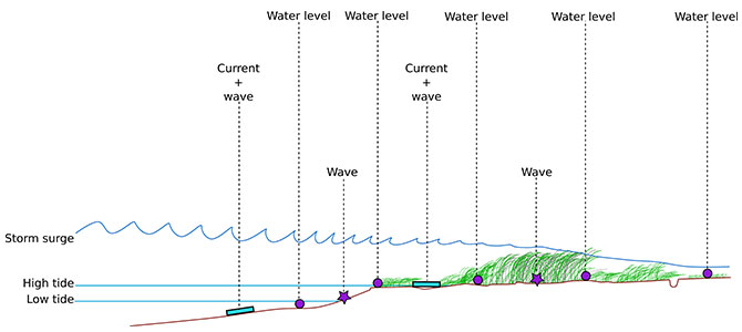
Graph of attenuation of water levels as surge moves through a marsh wetland from field monitoring in coastal wetlands of the U.S. mid-Atlantic to support quantification of storm surge attenuation at the regional scale: AGU Fall Meeting, 2015.
Designing engineering systems that provide lasting coastal protection for the built environment that don't negatively impact the ecological and environmental health of the coastal environment is key.
Data Collection: Waiting for the Storms
A lack of relevant data has slowed the incorporation of nature-based solutions in infrastructure: coastal engineers must be able to calculate the performance of every component included in the design in order to create resilient, cost-effective solutions.

Installing equipment to measure waves, currents and water levels in a marsh on the Delmarva Peninsula with Dr. Ferreira and the Flood Hazards Research Lab.
As a graduate student at George Mason University (GMU), I worked with Dr. Celso Ferreira on a combined modeling/monitoring effort to quantify the potential of marshes to protect coastal communities from varying degrees of coastal storms. Beginning in 2013, we deployed field instruments to continuously monitor hydrodynamic conditions (waves, currents and water levels) in wetlands of the Chesapeake Bay and Eastern Shore to capture the impacts of events including Hurricane Joaquin (2015), Hurricane Matthew (2016), Hurricane Hermine (2016), and Winter Storm Jonas (2015). You can check out some of the results of this study in the following scientific journals: Natural Hazards, Estuaries and Coasts, Ocean and Coastal Management, and Limnology and Oceanography. This important work has begun to fill a gap in the literature while at the same time providing needed data to coastal engineers seeking to integrate nature-based features into analysis and design.
Partnering with George Mason University
University partners are key players in developing the science supporting resilience studies. Academic and research engineers excel at identifying areas in need of study, adding literature to the canon used to inform the work done by consulting engineers. At the same time, consulting engineers work on large-scale studies that, in the course of analysis, expose areas where more research is needed. For this reason, maintaining effective, lasting partnerships between research and consulting engineers is a priority for advancing shared goals.
Engineers from our resilience solutions group have been working with the researchers at the Flood Hazards Research Lab at GMU over the past year to formalize collaboration via shared projects. A major aspect of this collaboration is the development of tools designed to facilitate analysis of flood hazards in riverine and coastal areas. Check out an example of some open source tools in development in the GMU-DevTools repository on our GitHub page!