All across the continental U.S. there are various points that collectively determine gravity measurements. This data makes up what's known as the vertical datum, the current system of zero elevation surfaces on topographic maps. The National Oceanic and Atmospheric Association's (NOAA) National Geodetic Survey (NGS) launched the Gravity for the Redefinition of the American Vertical Datum (GRAV-D) project in 2007 to reevaluate the outdated vertical datum. GRAV-D is driven by the fundamental connection between Earth's gravity field and what we consider to be the definition of height. The gravity field is the unseen force field that exists in the space around every mass on Earth. The project will model and monitor Earth's gravimetric geoid, a surface of the gravity field that is relative to the global mean sea level. The geoid serves as a zero reference surface for all heights across the nation. A key goal of the project is to create and maintain an accurate geoid to serve as the basis for the new vertical datum.

The Beechcraft Super King Air 200 (N43U) is used to collect the high-resolution "snapshots" of gravity. Image courtesy FlightAware.
Gathering Data
The GRAV-D project successfully collects and uses airborne gravity observations to model the geoid. The organization of the various flight plans is an integral part to completing this project on time and within budget. Our team is managing a contractor aircraft that is conducting the measurements using NGS equipment, including a turnkey airborne gravity system gravimeter and global navigation satellite system technology that provides continuous 3-D position, velocity, and altitude determination. In order to determine the vertical datum, there are two data collection methods, a high-resolution "snapshot" of gravity that is mainly an airborne mission and a low resolution "movie" of gravity changes, which will likely be a terrestrial mission, that focuses on monitoring geographic-dependent changes to gravity over time. Our team has effectively managed airborne efforts since 2014, and to date we have supported the completion of gravity measurements for Tucson, Arizona; Northern Mexico; Alaska; Palm Springs and the coast of California; and Lubbock, Texas for a total of 979 flight hours.

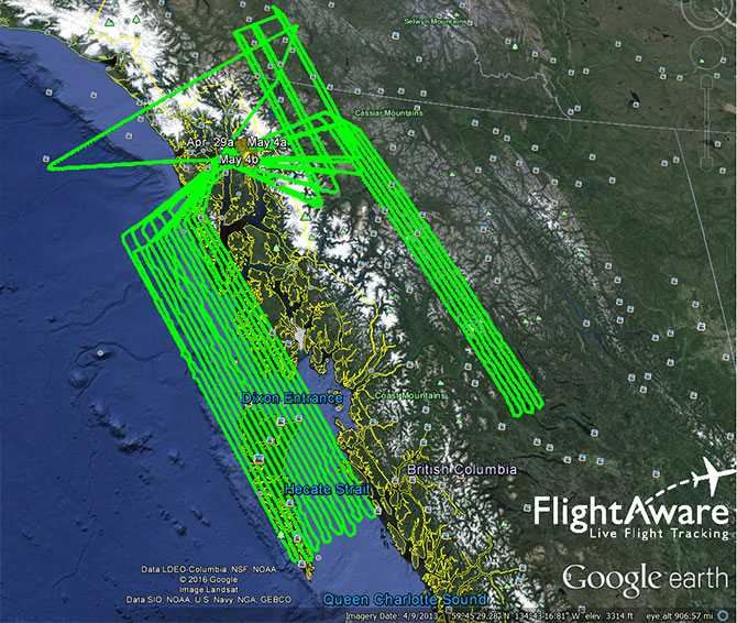
The recent flight paths over Alaska show the precision needed for accurate measurements. Image courtesy FlightAware.
An Accurate Vertical Datum
The benefit of updating the accuracy of the vertical datum is significantly improved height measurements, which affect many applications such as floodplain mapping, coastal resilience efforts, emergency management, precision agriculture, and could help us understand localized sea level changes.
With an updated vertical datum, the information will allow better mitigation of threats to low-lying communities and coastal ecosystems from inundation by storms, flooding, tsunamis, and sea level rise. It will also support the surveying community by providing more accurate heights from advanced technology. A socio-economic study conducted on behalf of NOAA estimates the GRAV-D project will save the nation $4.8 billion over 15 years once the project is completed, with $2.2 billion in avoidance costs from improved floodplain management alone. We are proud that our contribution to redefining the vertical datum will help improve the resilience of communities across the U.S.