Following the devastation of Superstorm Sandy in the northeast in 2012, funding for disaster resilience became available through the Disaster Relief Appropriations Act of 2013. A portion of that funding went through the Department of Interior's National
Park Service to further the protection of historic and cultural resources in the face of natural disasters.
After receiving an $8 million grant, the Connecticut State Historic Preservation Office (SHPO) quickly determined that they did not have sufficient data to inventory historic and cultural resources in harm's way, nor did they have a framework to handle
a grant of that size.
With mostly paper archives and a lack of GIS resources, the SHPO turned to us, through a team led by R. Christopher Goodwin & Associates, to develop a system and provide the tools that would allow them to accurately catalogue and geospatially identify
the state’s historic and cultural resources. The resulting project would represent the nation’s first statewide historic and cultural resources resilience program and impact how we approach protecting these resources around the country.
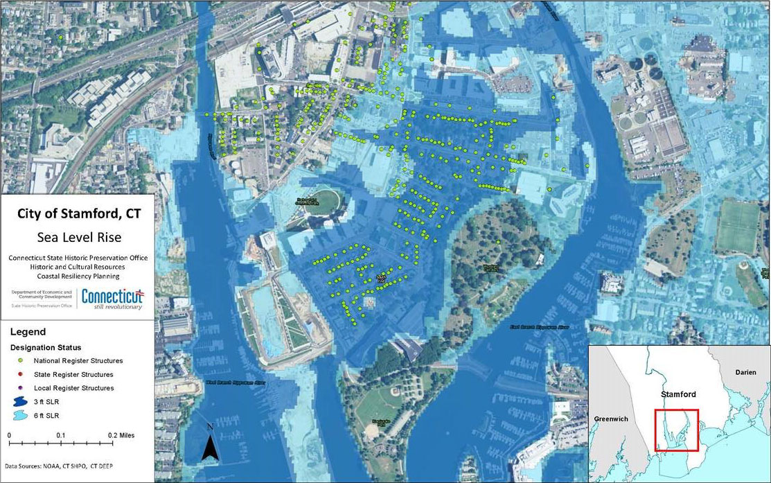
This figure illustrates the number of buildings currently on a state or national historic register that will be inundated by projected sea level rise scenarios in the city of Stamford.
Acquiring the Necessary Tools
Over the course of three months, our team went through and digitized the entire inventory of four targeted coastal Connecticut counties. In total, these counties contained over 3,200 historic resources. Following their digitization, we turned these resources
into a GIS layer through spatial analysis, allowing the SHPO to easily identify which resources could be affected by disasters.
Planning Assistance
Next, we performed a gap analysis of planning, policy, and regulatory documents in 91 municipalities to find out if their cultural and historic resources preservation programs were addressing natural hazard resilience at an ideal level. We conducted a
series of planning charrettes with municipal and regional planning agencies where we provided overlays of flood prone areas and two different sea level rise scenarios. We addressed wind and winter storms more qualitatively.
The purpose of the gap analysis was to figure out the answers to three questions.
- What are they doing to prepare for disasters?
- What are they doing with regard to historic preservation?
- What’s the nexus?
The purpose of the charrettes was to help determine the logical direction for filling the identified gaps.
We found that the communities do a pretty good job of disaster resilience planning and historic preservation individually, but they’re not considering historic preservation in their disaster planning or vice versa. We prepared background reports
on the gap analysis for 28 of the 91 communities, with tailored recommendations for closing the gaps during future planning and regulatory updates. We met with each of the 28 communities and presented our recommendations to gain their input. Ultimately,
we handed off the reports, along with the GIS inventory so that they can have that data at their fingertips and use it for different types of planning and analysis.
Although our work focused on the four coastal counties, we also contributed to a best practices guide for municipal governments statewide that outlined what can be done to protect their resources from disasters. We also helped to create a chapter for
the State Historic Preservation Plan dedicated to resilience planning—which, to our knowledge, had never been done before.
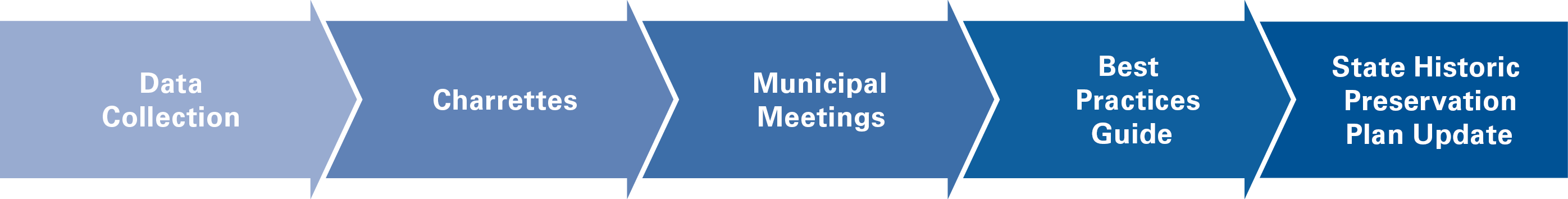
This graphic shows the sequence of the project from data development and collection to inform decisions, through local planning support.
A Lasting Project Legacy
Ultimately, this project stands out for being the first statewide program to examine historic and cultural resource preservation in the context of disaster resilience. Several cities and states are starting to follow suit by compiling an inventory and
analysis of their at-risk cultural and historic resources. Since the conclusion of the project, we’ve seen replication on different scales in other communities and states because it’s repeatable and scalable. The project is also starting
a dialogue that provides some much needed urgency to addressing disaster preparedness and response to protect our history. In short, it was a relatively simple project that promises to have big results.