The New York City Subway is one of the most extensive transportation systems in the world, with 468 passenger stations, 229 miles, and an average of seven-million daily commuters. On August 8, 2007, a severe rainfall event occurred during the morning rush hour, affecting various New York City Transit (NYCT) facilities—stations, shops, yards, and bus depots. The unprecedented rainfall amounted to approximately 3.5 inches; far exceeding the capacity of the city's storm sewers. Every subway line experienced some sort of delay and 33 subway stations were completely flooded. Additionally, flooded roadways affected bus routes, impacting more than two million users.
As a result of the flooding, NYCT selected Dewberry to conduct a system-wide flood study to identify the extent of vulnerability to storm flooding—including climate change impacts—throughout the subway system and key NYCT operational facilities.
Future Climate Change Impacts
Over time, it's predicted that New York City will be significantly impacted by flooding in the streets, sewers, and subways due to increased precipitation resulting from climate change.
- Temperature Rise: The earth's atmosphere contains many greenhouse gases, including carbon dioxide, that allow sunlight to enter the atmosphere and trap heat inside
- According to the Climate Risk Information (CRI) Report by the New York City Panel on Climate Change (NPCC), anticipated temperature rise by 2080 is 3 degrees Fahrenheit
- Precipitation: As the atmosphere gets warmer, it can hold more moisture, leading to increased rain, snow, or hail
- By 2080, the CRI Report anticipates an increase of rainfall intensity by 10 percent
- Sea Level Rise: Increased temperatures in the atmosphere cause the melting of glaciers and snow caps on mountains resulting in rise in sea level
- According to the CRI Report, the anticipated rise in sea level by 2080 is about 23 inches
Climate Change Impacts on Transit Operations: Metro-North Railroad's Hudson Line
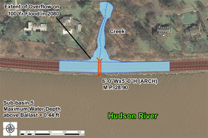
As part of the Metropolitan Transportation Authority, the Metro-North Railroad's Hudson Line is a commuter rail line with service points running north from New York City along the east shore of the Hudson River. With such close proximity to the river, flooding of the train tracks is a major concern. To address the issue, we conducted a pilot study that examined the potential effects of climate change to flooding along the Hudson Line, specifically.

Our Flood Threat Assessment details the flood vulnerabilities along Metro-North's Hudson Line within the pilot study project limits. The extent of overflow has substantially increased due to climate change; however, the water level along the Hudson River is still below the train track. Flooding can be reduced by installing additional drainage structures to increase the drainage capacity.
Noting the predicted climate change impacts on flooding in the CRI Report, increased precipitation will make New York City's subway system increasingly vulnerable to flooding. NYCT must prepare their subway facilities for such flooding events, in order to avoid further disastrous impacts.