Puerto Rico’s Caribbean location and topography create a landscape prone to riverine flash-flooding and coastal storm surge. Combined with decades of dramatic urban development, a significant population is at risk of devastating flood damage from both tropical systems and heavy showers and thunderstorms. Therefore, there is a critical need for communication and planning tools available to describe the risk a particular property or neighborhood faces.
Recognizing these needs, the Puerto Rico Planning Board (PRPB) initiated the development of a web-based application (GeoRiesgo) for the communication of flood risk that was expected to motivate household action, catalyze new planning efforts, and increase overall awareness.
GeoRiesgo now provides the public, planners, and decision makers, with a simple and accessible platform for viewing and quantifying flood risk at the local level. The initial phase, completed by Dewberry in 2011, provided a means to:
- provide a comprehensive view of flood hazard in Puerto Rico, seamlessly incorporating data captured from Google Maps, PRPB (building footprints), and FEMA (base flood elevations, special flood hazard areas, LiDAR datasets)
- provide reporting capabilities for changes in flood hazard at a structural level
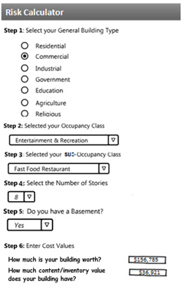
GeoRiesgo is entering a new phase of development (screenshot below) which will build on top of the flood hazard communication framework to provide the user with a flood risk calculator (FRC). User input is key for this calculator. Unlike many risk assessments that use off-the-shelf software packages that make assumptions about the built environment based on Census data, the FRC allows the user to specify the type and value of the structure being assessed. This provides a more robust risk assessment that can be tied to future mitigation options, providing local government and homeowners with real, actionable options to reduce flood losses.
Along with Milver Valenzuela, I will be presenting on GeoRiesgo and the FRC at the American Water Resources Association GIS Specialty Conference in New Orleans, March 27. If you’re attending, we’ll be available to answer any questions you may have.

Working much like a mortgage or car loan calculator, the FRC will be used to perform estimations of losses at the structural level, using a variety of inputs and algorithms, such as building flood depths and depth-damage functions.