For the past ten years, we have supported federal agencies and the State of Alaska in
mapping “America’s Last Frontier.” The largest state in the U.S. at more than 663,000 square miles, Alaska was also the only state that had never been mapped to national map accuracy standards. Inaccurate maps presented enormous challenges to aviators, first-responders, businesses, natural resources managers, and others needing to navigate the state’s rugged and diverse terrain.
Working closely with the Alaska Mapping Executive Committee and the U.S. Geological Survey (USGS), we’re nearing completion of
this ambitious statewide challenge. At the outset, we recognized that the clouds, fog, ice, haze, and smoke prevalent in the region precluded the use of traditional satellite or aerial image mapping. We proposed the use of Interferometric Synthetic Aperture Radar (IFSAR), which maps through these adverse weather conditions to deliver hydro-enforced Digital Terrain Models (DTMs) and Digital Surface Models (DSMs) as well as high-resolution Ortho-rectified Radar Images (ORIs). Today, topographic data and imagery for all but two percent of the state, consisting of several remote islands and the Western Aleutians, has been acquired and most of the map products have been delivered.
By Land and By Sea
The U.S. is examining the economic, environmental, security, and geopolitical implications of an unprecedented result of the extensive melting of polar ice that has created vast open waters in the Arctic Ocean during the summer months. Because of the melting, the Northwest Passage shipping channels between Atlantic and Pacific ports are opening without the need for icebreakers. The potential for expanded sea lanes across the Arctic would shorten some shipping routes—from China to Europe, for example—by thousands of miles. This has led to broad international interest for trade purposes—provided the routes are accurately charted and there are ports of refuge when maritime emergencies occur, as they surely will.
For maritime safety, the Northwest Passage is poorly charted and known to be no deeper than 15 meters (49 feet) in some locations that have been surveyed. This is shallower than the depths required for many of the larger supertankers and container ships that transit other maritime routes. In recent years, increasingly larger cargo and passenger ships have been using this Northwest Passage between Atlantic and Pacific ports. Unfortunately, Alaska currently has no acceptable deep-water port of refuge along this passage where large vessels could be diverted when an emergency occurs that makes it unsafe to sail further.
Among the important considerations for Alaska is its port and harbor infrastructure. Ports and harbors along the Northwest Passage will potentially see more frequent use by commercial ships as well as tourism cruises and other seafaring vessels. As a result, high-resolution hydrographic maps, including detailed information on water depth and coastline features, will be critical. Maps will also be needed to depict port-related transportation infrastructure systems such as roads and railways that will need to be developed. But it is difficult to justify the high costs for development or expansion of ports and harbors if only rarely used to assist commercial ships for safety reasons. These ports also need to be destination ports for economic reasons.
Port Clarence Pilot Project
As Alaska completes its statewide IFSAR mapping program, new opportunities to apply this technology have surfaced for addressing the potential for new or expanded ports and harbors. On the Seward Peninsula, near the Bering Strait, Nome and Port Clarence are both currently too small and shallow to serve as ports of refuge for large ships with deep drafts. Both are likely to see increased shipping traffic in the future. Are there other economic factors that might justify the cost of dredging and expanding these ports so they could handle larger ships?
In consultation with Dewberry, the Governor of Alaska saw the possibility of expanding Port Clarence because of economic development needs to export raw materials. Alaska has a wealth of untapped natural resources to be developed. As 3DEEP geophysical processes and explorations are used to identify oil and gas resources, rare minerals, or other raw materials, Alaska’s IFSAR data will provide a valuable tool for determining transportation routes to future ports, highways, or railroads. We believe that the potential for economic development will help decide where port and harbor infrastructure can be developed with the highest return on investment to address Alaska’s rapidly evolving needs for maritime commerce and expanded infrastructure.
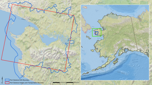
Through the USGS Geospatial Products and Services contract, we were tasked with mapping 3,302 square miles that included Port Clarence and the Graphite Creek Mine areas. The pilot project used IFSAR DSMs and DTMs and high-resolution (62.5-cm) IFSAR Ortho-rectified Radar Imagery to pan-sharpen (5m) RapidEye satellite imagery to update the transportation network and the National Hydrography Dataset (NHD) to 1:25,000-scale NHD and NHDPlus products. This challenging effort demonstrated the successful integration of orthoimagery, elevation, hydrography, and transportation data for the first time in Alaska, with tools provided for users to view any or all of the layers in 3D perspective.